United States • UNESCO World Heritage Site
Grand Canyon National Park: Rim Viewpoints, Colorado River & Hiking
1,857-Meter-Deep Gorge Carved Through Ancient Rock
Inscribed: 1979
Category: Natural
ID: #75
What Is Grand Canyon National Park and Why Visit?
The Colorado River carved the Grand Canyon through 2 billion years of rock layers over 5-6 million years, creating Earth's most spectacular geological cross-section that reaches nearly 1,857 meters deep and extends 446 kilometers across the Colorado Plateau. The layered formations expose ancient Precambrian basement rocks through Paleozoic sediments documenting marine transgressions, tectonic uplift, and erosional processes that reveal fundamental insights into our planet's evolution. The canyon supports five distinct life zones spanning from Sonoran Desert lowlands at the river to boreal forests on the North Rim, providing essential habitat for California condor recovery populations and endangered humpback chub endemic to the Colorado River, while isolated micro-environments support unique evolutionary adaptations across 1,500 meters of vertical relief.
Why It Matters
Grand Canyon demonstrates superlative natural phenomena and outstanding geological processes spanning nearly half of Earth's history through incomparable erosional landscapes. Its layered rock formations reveal exceptional evidence of biological evolution, while supporting diverse ecosystems with rare and endemic species across extraordinary elevation gradients throughout five distinct life zones.
How to Visit Grand Canyon National Park
Essential information for visiting this destination
How to Get to Grand Canyon National Park
Las Vegas 275 kilometers west and Phoenix 360 kilometers south provide nearest major airports with rental cars essential for national park access given limited public transport. South Rim remains open year-round via Highway 64 with scenic Desert View Drive providing access to eastern viewpoints. North Rim accessed seasonally May-October via Highway 67 from Jacob Lake. Amtrak trains reach Flagstaff 130 kilometers south with shuttle services to South Rim. Within the park, free shuttle buses connect Grand Canyon Village viewpoints reducing vehicle congestion.
Best Hotels Near Grand Canyon National Park
Grand Canyon Village South Rim hotels including El Tovar historic lodge and Bright Angel Lodge deliver rim-edge positioning with canyon views, requiring booking 366 days ahead for peak summer season given extremely limited availability. Convenient shuttle and trail access justifies premium pricing.
Tusayan town 11 kilometers outside South Rim gates offers modern chain hotels with more availability and lower prices, though requiring vehicle transport for park access and lacking atmospheric character. Practical base for budget-conscious visitors.
Williams town 96 kilometers south provides vintage Route 66 character with mid-range motels and historic railroad access via Grand Canyon Railway, delivering nostalgic transportation experience while avoiding parking challenges. Significantly more economical than in-park lodging.
Where to Eat Near Grand Canyon National Park
South Rim dining emphasizes Southwestern cuisine including Navajo tacos, green chile stew, and mesquite-grilled steaks reflecting regional flavors developed over generations through indigenous and Hispanic influences. El Tovar Dining Room serves upscale fare in historic setting with panoramic canyon views while cafeteria and snack bars provide budget options for casual meals between explorations. Williams and Flagstaff gateway towns offer authentic Mexican and Native American-influenced restaurants showcasing local ingredients and traditional cooking methods. Pack provisions for backcountry adventures given limited food options at remote locations. Vegetarian options increasingly available throughout park facilities catering to dietary preferences while maintaining Southwestern culinary authenticity.
Grand Canyon National Park Entry Fees & Tour Prices
Park entry costs $35 USD per vehicle (7-day pass) or $20 USD per person for cyclists/hikers. America the Beautiful annual pass costs $80 USD providing excellent value for multi-park trips. Senior passes (62+) cost $20 USD annually or $80 USD lifetime. Multi-day Colorado River rafting expeditions cost $2,800-4,500 USD for motorized trips (6-8 days) or $3,500-5,500 USD for oar-powered trips (12-18 days), requiring 12-18 months advance booking. Backcountry permits cost $10 USD per permit plus $8 USD per person per night. Phantom Ranch overnight lodging costs $62-166 USD. Mule rides to Phantom Ranch cost $742 USD for 2-day/1-night trips including meals and lodging. Scenic helicopter tours from Tusayan cost $229-329 USD for 25-50 minute flights. Grand Canyon Railway from Williams costs $67-226 USD round-trip. Guided day hikes cost $125-175 USD per person for 4-6 hour ranger-led explorations. Desert View Watchtower, Yavapai Geology Museum, and Tusayan Ruin offer free entry. Ranger-led programs operate daily at no charge.
What to Bring to Grand Canyon National Park
Comprehensive travel insurance covering emergency medical evacuations essential given remote location and challenging rescue operations from canyon depths requiring helicopter transfers to advanced facilities. International eSIM cards provide cellular connectivity at Grand Canyon Village and developed South Rim areas, enabling emergency communication and navigation apps while backcountry areas lack coverage requiring offline maps and satellite devices. Book lodging 366 days ahead immediately when reservations open for summer peak season as in-park accommodation sells out within hours.
United States uses Type A and B electrical outlets (120V). Summer temperatures exceed 40°C at canyon bottom while rim stays moderate, requiring layered clothing and abundant water for hiking. Winter brings snow and ice closing North Rim entirely. Pack high-SPF sunscreen, wide-brimmed hat, and sturdy hiking boots for rough terrain. Altitude at 2,100 meters may affect visitors from sea level. Respect indigenous sacred sites and leave no trace principles protecting fragile desert ecosystems.
Loading map...
Visitor Information
Everything you need to know for your visit
What to Bring
Abundant water supply critical for hydration (minimum 4 liters daily), high-SPF sunscreen for intense desert sun exposure, wide-brimmed hat providing shade, sturdy hiking boots with excellent ankle support, layered clothing accommodating temperature extremes from 49°C at canyon floor to freezing at rim, high-energy snacks, offline maps and GPS devices, comprehensive emergency supplies for below-rim hiking adventures
Accessibility
South Rim largely wheelchair accessible with paved rim trails including Rim Trail segments and free shuttle buses featuring wheelchair lifts and designated seating areas. Major viewpoints including Mather Point and Yavapai Point offer accessible viewing platforms with railings. Visitor centers provide mobility assistance, accessible exhibits, accessible restrooms, and parking spaces throughout village area.
Safety Tips
Heat exhaustion causes most canyon emergencies--carry minimum 4 liters water daily and drink before feeling thirsty. Never attempt same-day hikes to the Colorado River; the 1,400-meter elevation gain causes fatalities annually. Temperatures range from 49°C at canyon floor to freezing at the rim. Stay behind railings as crumbling edges have caused fatal falls. Monsoon season (July-September) brings flash flood danger.
Geological Wonders and Natural Phenomena
Must-See
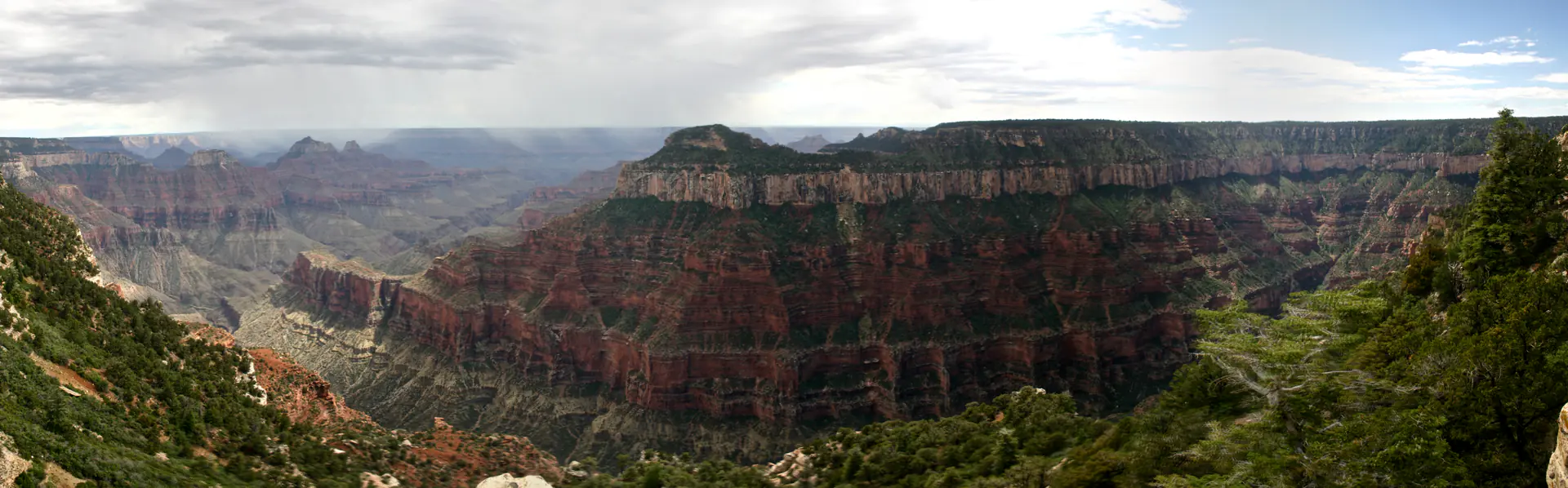
South Rim Panoramic Viewpoints
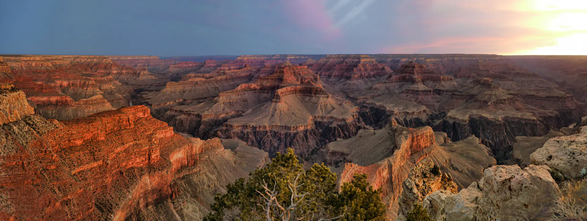
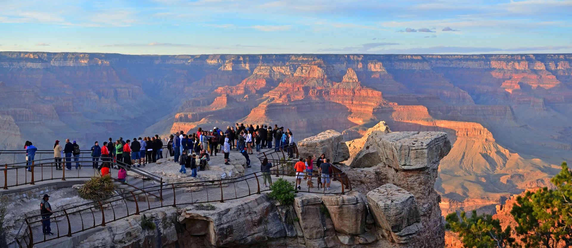
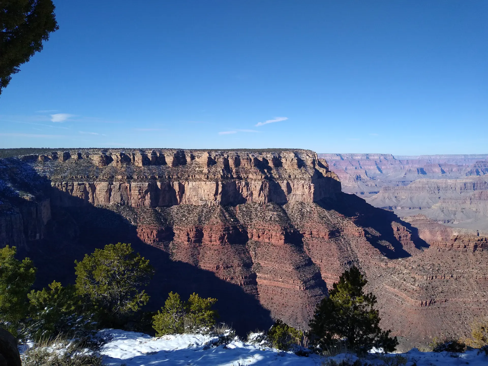
The South Rim delivers the most accessible Grand Canyon perspectives, with Mather Point serving as the iconic first encounter where the canyon's immense scale becomes immediately apparent. This viewpoint showcases classic vistas with Paleozoic rock formations creating distinct color bands from cream Kaibab limestone through red Supai formations to dark Vishnu basement rocks. The accessible 13-kilometer Rim Trail connects multiple viewpoints including Yavapai Point with its geology museum, Hopi Point offering spectacular sunsets, and Hermits Rest at the western terminus. These perspectives demonstrate how the Colorado River carved through sedimentary layers while tributaries created complex temples, buttes, and amphitheaters defining this extraordinary sculptural landscape.
Pro tip: Visit Hopi Point 1 hour before sunset (6-8pm depending on season) for the most spectacular rim views--the western orientation creates dramatic shadows across canyon formations while avoiding the Mather Point crowds where most tour buses gather.
Must-See
Ancient Geological Rock Layers
The Grand Canyon exposes Earth's most complete geological record, with 40 distinct rock layers revealing 2 billion years of planetary history through exceptionally preserved sedimentary sequences. The Great Unconformity represents a 1.2 billion year gap where Precambrian Vishnu schist contacts Cambrian Tapeats Sandstone, documenting massive erosional episodes. Overlying Paleozoic formations including Bright Angel Shale, Redwall Limestone, and Coconino Sandstone preserve ancient marine environments, desert dunes, and coastal plains through distinctive fossils. Each layer reveals changing climates, advancing seas, and evolving life forms from Precambrian stromatolites through Paleozoic marine invertebrates. This spectacular cross-section allows visitors to walk through geological time while witnessing ongoing erosional processes exposing deeper formations.
Pro tip: Visit Yavapai Geology Museum (free entry) at Yavapai Point to understand the rock layers before viewing them--the museum's labeled canyon panorama and exhibits make identifying formations easy when you walk the Rim Trail afterward.
Must-See
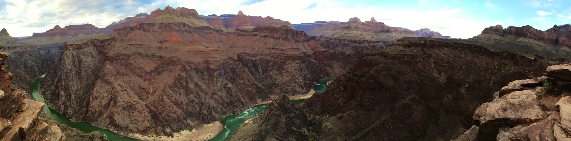
Colorado River Journey Experience
The Colorado River carved the Grand Canyon through persistent erosion over 5-6 million years, transporting massive sediment loads while continuing to deepen the chasm at measurable rates. Multi-day rafting expeditions provide intimate perspectives on ongoing geological processes, accessing remote side canyons and ancient indigenous sites while navigating powerful rapids created by tributary debris flows. Lava Falls represents one of North America's most challenging whitewater rapids, while calmer sections reveal towering canyon walls rising from river level. River trips descend through climate zones from cool rim forests to scorching inner canyon temperatures exceeding 43°C, experiencing all major geological formations from perspectives impossible to achieve from rim viewpoints.
Pro tip: Book motorized rafting trips (6-8 days, $2,800-4,500) rather than slower oar-powered trips (12-18 days) for first-timers--you'll experience the same major rapids and side canyons while using less vacation time, though book 12-18 months ahead as commercial permits sell out rapidly.
Recommended
North Rim Wilderness Solitude
The North Rim offers dramatically different perspectives at higher elevations (2,438 meters versus 2,134 meters) with lush ponderosa pine and aspen forests creating a wilderness atmosphere receiving only 10% of visitors. North Rim viewpoints including Bright Angel Point and Cape Royal provide spectacular vistas while looking down into side canyon systems. The cooler climate supports different communities including Kaibab squirrels found nowhere else, representing isolated evolution. Challenging hiking trails like the North Kaibab Trail offer solitude and pristine experiences while demonstrating how elevation creates dramatically different ecosystems.
Pro tip: The North Rim (open mid-May to mid-October only) provides a completely different Grand Canyon experience with 10% of South Rim crowds--if visiting June-September, spend one night at Grand Canyon Lodge to experience sunrise at Cape Royal and sunset at Bright Angel Point without the 350-kilometer drive around the canyon.
Recommended
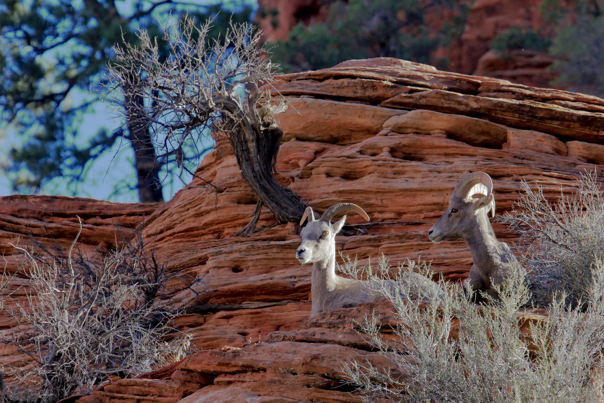
Desert Bighorn Sheep and Wildlife Diversity
Grand Canyon supports extraordinary biodiversity across five distinct life zones from Lower Sonoran desert scrub to Hudsonian spruce-fir forests. Desert bighorn sheep navigate steep canyon walls with remarkable agility, representing successful conservation efforts while California condors soar on thermal updrafts demonstrating endangered species recovery. The park protects 91 mammal species including mountain lions, elk, and mule deer alongside 447 bird species, 56 reptile and amphibian species, and 1,750 plant species. This exceptional biodiversity reflects dramatic elevation gradients creating compressed life zones while research documents climate change impacts.
Pro tip: Early morning Rim Trail walks (6-8am) offer the best wildlife viewing opportunities--mule deer graze along the rim, California condors soar on morning thermals (9-foot wingspan unmistakable), and bighorn sheep frequent water sources near Pipe Creek Vista on the South Kaibab Trail.
Historical Context
Indigenous Peoples Heritage (12,000+ years)
Archaeological evidence documents continuous human presence for at least 12,000 years, with ancestral Puebloan peoples inhabiting canyon areas before 1300 CE. Modern Havasupai, Hualapai, Navajo, Hopi, Paiute, and Zuni nations maintain deep spiritual and cultural connections through sacred sites and ongoing traditions.
Spanish and American Exploration (1540-1869)
Spanish conquistadors under García López de Cárdenas became the first Europeans to view the canyon in 1540. Major John Wesley Powell led the first documented river expedition through the canyon in 1869, creating detailed geological observations and maps that sparked scientific interest.
Tourism Development Era (1870-1919)
Railroad arrival in 1901 transformed Grand Canyon into a major tourist destination with development of hotels, viewpoints, and infrastructure. Fred Harvey Company and architect Mary Colter created culturally-influenced structures including Desert View Watchtower integrating indigenous architectural motifs.
National Park Protection (1919-1979)
Grand Canyon National Park establishment in 1919 provided federal protection, with expanded boundaries protecting entire watershed ecosystem. Civilian Conservation Corps developed visitor infrastructure during the 1930s including trails, buildings, and rim facilities still used today.
UNESCO World Heritage Designation (1979)
UNESCO World Heritage inscription in 1979 recognized the canyon's outstanding universal value for geological processes, superlative natural phenomena, and biological diversity across extraordinary elevation gradients. International recognition strengthened protection against external threats including proposed dams and development projects while enhancing global awareness.
Modern Conservation Challenges (1979-present)
Contemporary management balances substantial visitation (exceeding 6 million annually in peak years 2017-2019, approximately 4.7 million in 2023) with ecosystem protection, addressing uranium mining threats, invasive species control, California condor recovery, and climate change adaptation while maintaining indigenous peoples' cultural connections and access rights.
Conservation
Current Status
Protected as a U.S. National Park with comprehensive UNESCO World Heritage oversight, implementing ecosystem-based management strategies balancing preservation of geological processes and biological diversity with sustainable visitor access and indigenous cultural rights.
Challenges
- Climate change impacts including altered precipitation patterns, increasing temperatures, and drought stress affecting water availability and ecosystem distributions
- Air pollution from regional sources reducing visibility and depositing atmospheric nitrogen affecting delicate desert plant communities
- Uranium mining proposals on adjacent lands threatening groundwater contamination of springs and seeps supporting unique endemic species
- Substantial visitor pressure (4-6 million annually) requiring careful crowd management protecting fragile rim and below-rim environments
- Glen Canyon Dam operations disrupting natural sediment transport and river flows affecting riparian ecosystems and beaches
- Invasive species including tamarisk and cheatgrass altering natural fire regimes and competing with native vegetation
- Aircraft noise from commercial air tours impacting wilderness character and wildlife behavior throughout canyon airspace
Conservation Efforts
- Comprehensive endangered species recovery programs successfully restoring California condor populations through captive breeding and release while monitoring desert bighorn sheep populations across canyon habitats
- Invasive species control programs targeting tamarisk removal and cheatgrass management protecting native plant communities through mechanical and biological control methods
- Colorado River ecosystem restoration through managed flow experiments coordinating with Glen Canyon Dam operations attempting to restore natural sediment transport and beach building processes
- Air quality monitoring programs tracking pollution sources and implementing regional partnerships reducing visibility-impairing emissions protecting pristine viewsheds
- Sustainable tourism initiatives including shuttle systems, timed entry considerations, and Leave No Trace education programs reducing environmental impacts from millions of annual visitors
- Tribal consultation and co-management programs respecting indigenous peoples' cultural connections while incorporating traditional ecological knowledge into contemporary conservation strategies
- Extensive geological and ecological research partnerships with universities and research institutions advancing understanding of climate change impacts, erosional processes, and ecosystem adaptations
Frequently Asked Questions
Grand Canyon is a massive gorge carved by the Colorado River over 5-6 million years, exposing 2 billion years of geological history through spectacular layered rock formations. Famous for its immense scale at 446 kilometers long and 1,857 meters deep.
South Rim at 2,134 meters elevation remains open year-round with extensive facilities serving 90% of visitors, while North Rim at 2,438 meters operates seasonally offering wilderness solitude and lush forests. North Rim provides different canyon perspectives with fewer crowds.
Park entry costs $35 per vehicle for 7 days. Budget travelers spend $150-250 daily including Tusayan lodging. Mid-range visitors spend $350-550 daily with South Rim lodges. Luxury experiences cost $700-1,500+ including El Tovar and helicopter flights.
El Tovar historic lodge and Bright Angel Lodge offer rim-edge positioning requiring 366-day advance booking for summer. Tusayan town (11km outside gates) provides modern chain hotels with more availability. Williams (96km south) offers vintage Route 66 character and significantly more economical lodging options.
Yes, book in-park lodges exactly 366 days ahead when reservations open. Summer peak season sells out within hours of release. Tusayan hotels book months ahead. Phantom Ranch overnight requires lottery permits booked months in advance. Plan early to secure rim-edge views and preferred dates.
Pack ample water, sun protection including hat and sunscreen, sturdy hiking boots, and layered clothing for temperature changes. Bring energy snacks, camera, and binoculars. Below-rim hikers need extra water, electrolytes, first-aid supplies, and emergency communication devices.
UNESCO World Heritage Criteria
Inscribed in 1979, this site meets 4 of UNESCO's 10 criteria for Outstanding Universal Value
VII
Criterion (vii): Contains superlative natural phenomena
The Grand Canyon contains superlative natural phenomena through its overwhelming scale reaching 1,857 meters deep and 29 kilometers wide, spectacular multi-colored rock layers creating one of Earth's most visually stunning landscapes, and the mighty Colorado River carving through ancient geology in displays of raw natural power.
VIII
Criterion (viii): Outstanding geological processes
The canyon represents an outstanding example of Earth's geological history, exposing nearly two billion years of rock layers from Precambrian basement through Paleozoic sediments, documenting tectonic uplift, marine transgressions, and erosional processes that reveal fundamental insights into our planet's evolution and formation.
IX
Criterion (ix): Outstanding ecological/biological processes
The site demonstrates outstanding ecological processes through five distinct life zones spanning from Sonoran Desert lowlands to boreal forests on the North Rim, showcasing elevation-driven biodiversity across 1,500 meters of vertical relief and adaptive strategies organisms employ across dramatically varied environmental gradients.
X
Criterion (x): Contains threatened species
Grand Canyon provides essential habitat for threatened species including California condor recovery populations, endangered humpback chub endemic to Colorado River, and over 1,750 plant species, while its isolated micro-environments support unique evolutionary adaptations and serve as critical refugia for desert-adapted wildlife.
Image & Content Attribution
Research & Content Sources
Photography & Visual Media
Michael Quinn, National Park Service, CC BY 2.0
Mx. Granger, CC0 1.0
Jonathan Fox, CC BY-SA 2.0
Jeff Turner, CC BY 2.0
ImagePerson, CC0
Last updated: 2 November 2025